
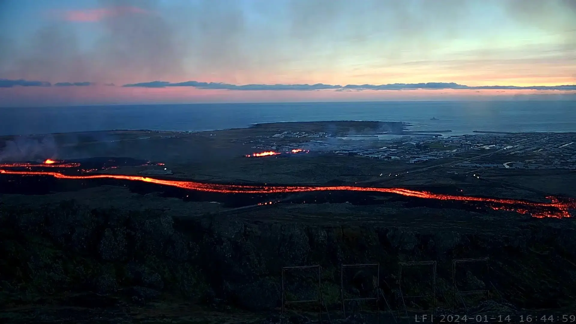
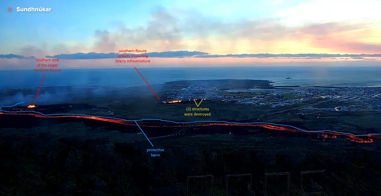
Iceland erupted again this morning at 7:57am Grindavik Time. The eruption was captured in real time. It again is a northwest linear fissure and is located west of Hagafell and a bit south of the prior eruption site in December.
While the locals had built a huge rock berm to protect some of it’s infrastructure, the fissure formed and spread underneath the berm, circumventing its protection. Everyone has been evacuated, though there are reports that despite being told not to bring any previously evacuated animals back to town, some may not have obeyed and now the animals may be locked up and in harms way.
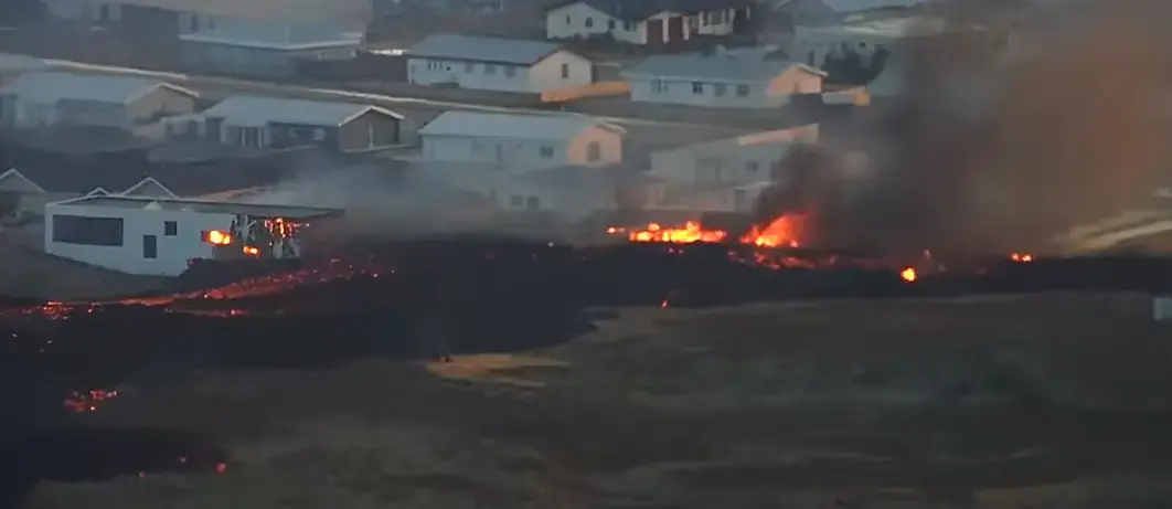
Additionally, a second fissure opened on the north edge of town. You can see this in real time on Professor Shawn Willsey’s live update from early this morning. This southern fissure is much smaller but is much closer to town. It has spewed forth enough lava that it has now contacted and destroyed (2) houses along the towns northern edge. It was one of the worst scenarios that could happen. This is likely just the beginning, and could signal the end of Grindavik as it now exists.
The northern fissure has ejected a huge amount of lava but most was deflected and contained by the berm. It has now breached the berm at the highway, which they plugged as best they could early this morning. All things considered, it was quite wise of them to do this. The greenhouse would likely have been destroyed already, and much more lava would now be heading towards Grindavik, which is downhill from both eruption sites.
.
A closeup of the initial damage from the new active lava flow
.
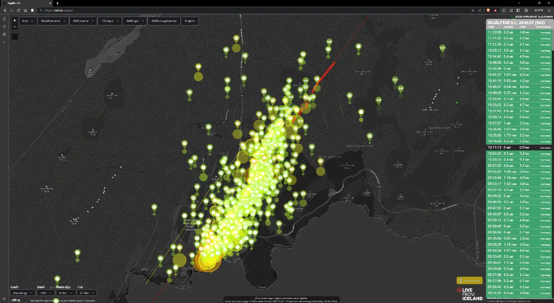
Earthquake map as of this morning. The quakes give you an idea of how big the magma chamber under the town is.
.
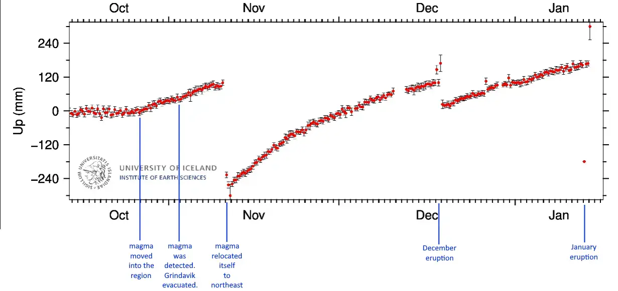
GPS Elevational Data over the campaign of this eruption
.
This is a very serious and dire situation. Whatever god you acknowledge, pray for the town of Grindavik to be spared. My heart goes out to the brave people of Grindavik.
The aftermath of the January 14 2024 volcanic eruption which has now officially been declared to be over.
The Map
This is a combination of Agust Gudmundsson’s Satellite Map and the 2D quake map. I used Autocad to import each image and then known features to match the scales and orientations, but it’s still an approximation. Additionally, the satellite image is greyscale and low resolution so the perimeter of the lava field gets hard to discern in some areas with little to no color contrast.
The Fissures and Lava Fields
The two eruptive fissures (north[900m] and south[150m]) are shown in red. It ejected quite a bit of lava, but the experts say they were lucky that the eruption was as weak as it was. The new lava fields from each are in orange. The initial fissure to the north grew in its size as the eruption continued and extended itself underneath the original berm. This extension and the area where the berm crossed the highway allowed lava behind the ber.
The southern fissure was completely unexpected and it was heartbreaking to witness. While it released a smaller amount of lava at a lower pressure than the north, but due to its proximity to the village, it was enough to destroy at least (2) homes.
The Berms
The berms are shown in blue, both the original (lite blue) and the two new additional ones (medium blue).
The original 10-15 meter high [32-48 foot] berm held up strong and most likely saved the village from much more damage. However, it was not completely effective. A small portion of the berm at the highway had been left open for travel until the day of the eruption when emergency crews plugged it last minute.
During and since the eruption, the emergency crews have built (2) new berms on the west side of Grindavik to further deflect lava and protect the village.
The Infrastructure
The town is still under evacuation order due to the uncertainty of future eruptions and the dangers inside the village due to subsidence and instability.
Electricity seems to be back on in town.
The geothermal pipeline that runs tandem (a few meters west) to the north-to-south highway and was destroyed by lava. This is significant in that this supplies Grindavik it’s most abundant heat source, hot water. Homes that were not in harms way are still going to have moderate damage due to frozen pipes. [Edit Jan 21 2024] It was reported that just yesterday emergency crews bypassed the destroyed section of pipe restoring water both hot and cold.
Two of the reported three homes that were destroyed by lava are shown in white. The north home does not appear on many maps. It was reported to be a new home that was yet unoccupied. The south home was occupied and appeared to be a complete loss. I am still unsure about the third home.
The greenhouse, shown in green, survived seemingly undamaged thanks the the original berm. It was reported to have had all of its equipment removed prior to the eruption.
I heard a report that the local government is probably going to be able to offer Grindavik residents a buyout for their homes and property but all I can find is a report that it may be possible.
250 abandoned sheep were reported to have been rescued and removed on Tuesday Jan 16.
The Next Chapter
The future of Grindavik is not looking so good. The data seems to point towards yet another eruption, and likely within the next few weeks.
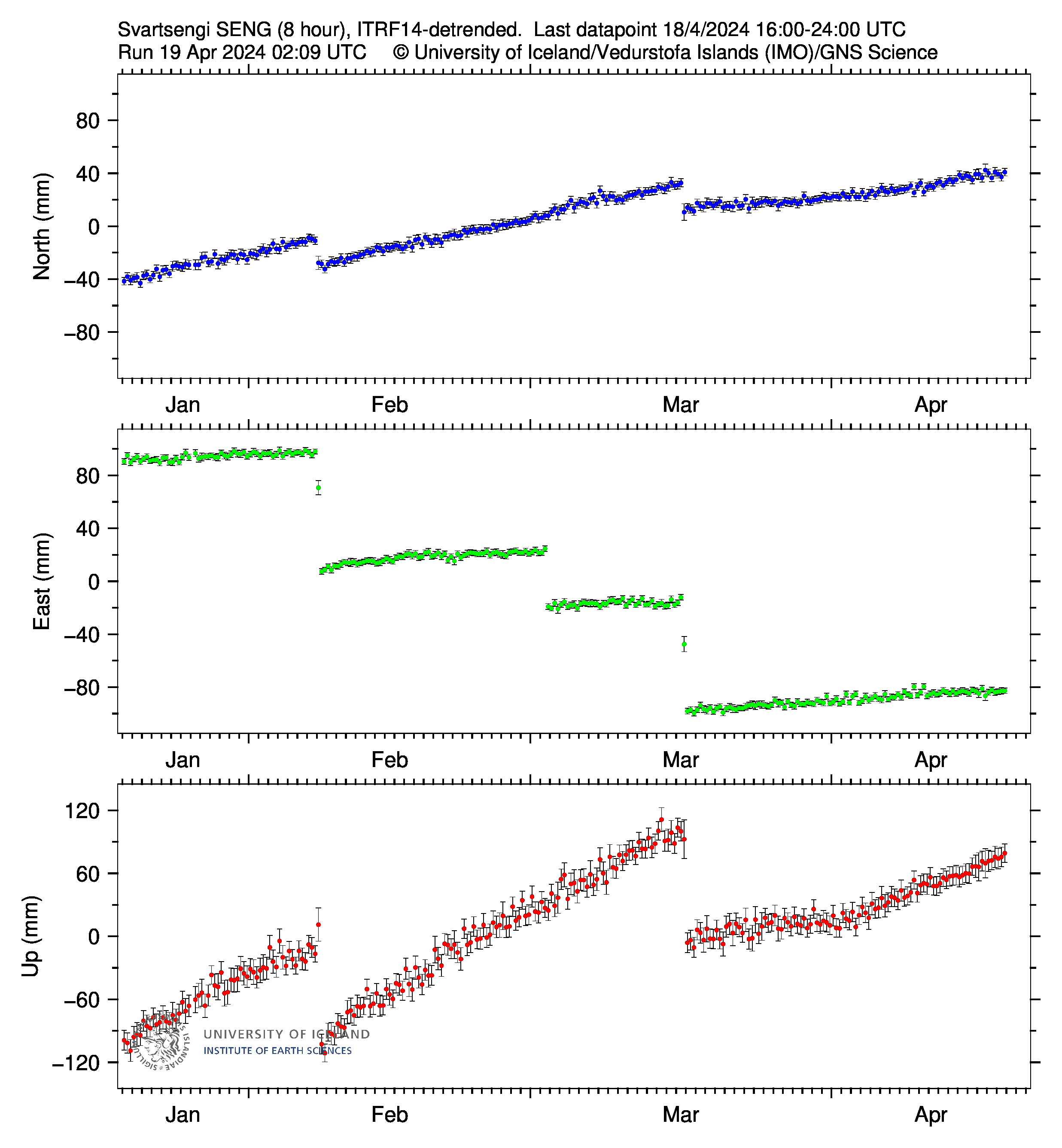
The Svartsengi GPS Station is near the power plant (north of Grindavik). This is the region where the experts suspect the ultimate source of the magma. It is feeding the magma chamber under Grindavik which is where the eruptive fissures from both December and January formed. It will take months or years of inactivity for this to cool and plug itself. While the system is fed, the pressure will increase. As the pressure builds, the chances of the magma moving or erupting increase. There is no real way known to man as to what exactly is going on down there.
Earthquakes have been very quiet in the area which is to be expected after the balance of pressure. They have ramped back up through the week but are still low in frequency, size and depth. During the eruption, there were numerous mini-clusters of earthquakes near Grindavik (Locations with a high concentration of earthquakes). One of these locations ultimately became where the southern fissure erupted. There were (2) other mini-clusters south of that fissure well inside of Grindavik. Both of these areas of mini-clusters are above the magma chamber and could be places of a future eruption. With the damage to the area, it could just be stress related fractures.
Send hope and prayers to the great and brave people of Grindavik.